Trail Walking Les Pradeaux - De l'Allier à l'Ailloux - Photo
 tracegps
tracegps

User

© OpenStreetMap contributors
Length
Length
11.5 km
Max alt
Max alt
420 m
Uphill gradient
Uphill gradient
122 m
Km-Effort
Km-Effort  
13.1 km
Min alt
Min alt
371 m
Downhill gradient
Downhill gradient
121 m
Boucle
Boucle
Yes
Creation date :
2014-12-10 00:00:00.0
Updated on :
2014-12-10 00:00:00.0

(1 Reviews)

Walking
Walking
3h00
Difficulty : Medium

Scan this QR Code to open this trail in the SityTrail application

FREE GPS app for hiking

Logo SityTrail SityTrail

IGN / Geographical institutes

Download SityTrail from the App Store Download SityTrail from Google Play

Logo SityTrail SityTrail World

The world is yours!

Download SityTrail from the App Store Download SityTrail from Google Play Download SityTrail on Huawei AppGallery

About

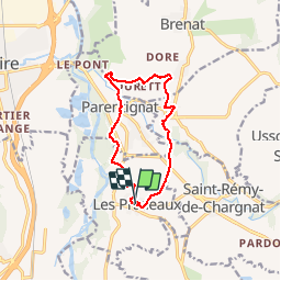
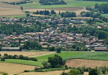
Trail Walking of 11.5 km to be discovered at Auvergne-Rhône-Alpes, Puy-de-Dôme, Les Pradeaux. This trail is proposed by tracegps.

Description

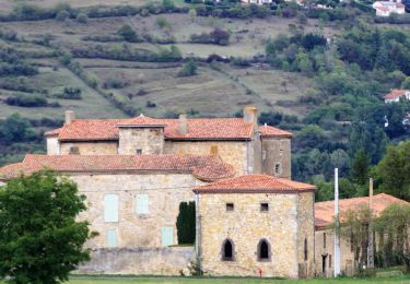
Itinéraire en bordure de l'Allier sans aucune difficulté. Le départ se fait devant le château de Parentignat des 17 et 18e siècles. Balade numérisée sur le terrain par Jean louis Phillipart. Retrouvez cette randonnée dans le topo Guide Chamina Au Fil de l’Allier.

Elevation profile

Photos

Positioning

Country:
France
Region :
Auvergne-Rhône-Alpes
Department/Province :
Puy-de-Dôme
Municipality :
Les Pradeaux
Location:
Unknown
Start:(UTM)
522993 ; 5039872 (31T) N.

Comments

Please log in to post a review or rate the element


Trails nearby

Trail Motor Issoire - monboissiers 2 - Photo
Motor
coppel

Motor

Medium
(1)
Issoire, Auvergne-Rhône-Alpes, Puy-de-Dôme, France
101 km | 129 km-effort
3h 0min
Yes
Trail Walking Brenat - Brenat_Tour_Gevillat - Photo
Walking
GUIDE
jagarnier

Walking

Easy
(1)
Brenat, Auvergne-Rhône-Alpes, Puy-de-Dôme, France
9.3 km | 11.9 km-effort
2h 45min
Yes
Trail On foot Lamontgie - Notre-Dame de Mailhat - Photo
On foot
PRO

On foot

Easy
Lamontgie, Auvergne-Rhône-Alpes, Puy-de-Dôme, France
8.4 km | 10.5 km-effort
2h 23min
Yes
Trail On foot Saint-Martin-des-Plains - Vallee de parcelles - Photo
On foot
PRO

On foot

Easy
Saint-Martin-des-Plains, Auvergne-Rhône-Alpes, Puy-de-Dôme, France
11.3 km | 13.8 km-effort
3h 8min
Yes
Trail On foot Usson - Le Pic d'Usson - Photo
On foot
PRO

On foot

Easy
Usson, Auvergne-Rhône-Alpes, Puy-de-Dôme, France
7.7 km | 9.6 km-effort
2h 11min
No
Trail On foot Brenat - La Tour de Gevillat - Photo
On foot
PRO

On foot

Easy
Brenat, Auvergne-Rhône-Alpes, Puy-de-Dôme, France
9.8 km | 12.6 km-effort
2h 52min
Yes
Trail Walking Nonette-Orsonnette - Nonette_Val_Allier - Photo
Walking
GUIDE
jagarnier

Walking

Medium
(1)
Nonette-Orsonnette, Auvergne-Rhône-Alpes, Puy-de-Dôme, France
9.9 km | 13.4 km-effort
3h 0min
Yes
Trail Motorbike Issoire - Rando ST Flour - Photo
Motorbike
coppel

Motorbike

Medium
Issoire, Auvergne-Rhône-Alpes, Puy-de-Dôme, France
227 km | 298 km-effort
7h 23min
Yes
Trail Moto cross Issoire - Sortie Ally avec cailloux et Olivier - Photo
Moto cross
coppel

Moto cross

Difficult
Issoire, Auvergne-Rhône-Alpes, Puy-de-Dôme, France
196 km | 253 km-effort
Unknown
No


Close
My subscriptions